XTatlasTM Is a ground-breaking expeditionary Unmanned Aircraft System Geo Spatial Tactical Ecosystem processing , exploitation and dissemination application.
XTatlas
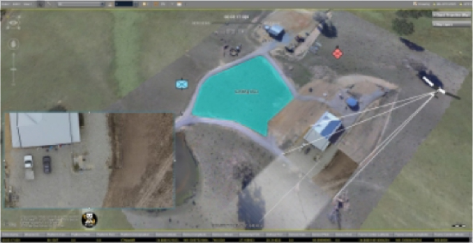
All-ISR and XTEC introduces XTatlasTM–XTEC’s ground-breaking expeditionary Unmanned Aircraft System Geo Spatial Tactical Ecosystem processing , exploitation and dissemination application. This new system’s application allows for real time, accurate geo-referenced video mapping. Traditionally, mapping accurate Georeferenced capabilities, cannot be conducted in real-time, and it take hours to compute data from a mission to match up to map references. XTatlas offers a real-time capability that allows the user to view georeferenced video providing the operator instant situational awareness during a Mission.
XTatlasTM consists of
STANAG 4609
MISB ST 0601.8 compliant high-definition video feed
Ground Control System (GCS) with XTatlasTM application installed.
The live video and geolocated maps can be transmitted over any compatible network for viewing at a remote command post.
XTatlasTM grants the UAS operator situational awareness of the area in which the mission is conducted. Background imagery can be utilized from sources such as satellite maps or any georeferenced image. If imagery of the area is unavailable, a mission can be conducted to create new imagery. This imagery can then be used for future missions and changes to the area of interest can be detected during and after mission completion.